CanadianGIS.com - Promoting Canadian geographic information

Canadian Map Gallery – 1895 Ottawa Panoramic Map

1895 Ottawa Panoramic Map

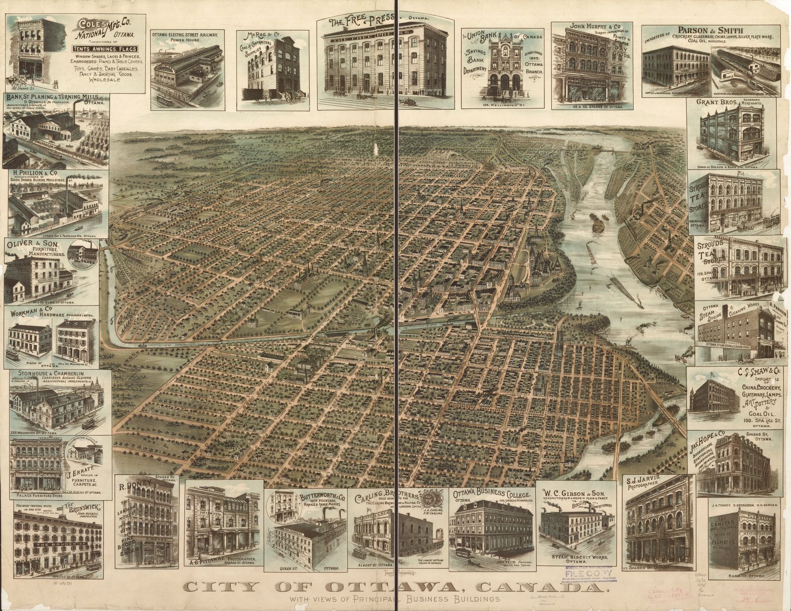
Title: City of Ottawa, Canada with views of principal business buildings

Date: 1895

Publisher: Toronto Lithographing Company

Map Dimensions:  83 cm x 106 cm

Image Source: Library of Congress, Geography and Map Division

This work is licensed under a Creative Commons License.

*** Image shown above is  low resolution, scroll down further on this page for a high resolution image that you can zoom into to see the finer details, as well as a download link, if you wish to print your own copy. ***

Notes: Panoramic view of the City of Ottawa published in 1895 by the Toronto Lithographing Company. It provides viewers an oblique aerial view in a south direction from the east looking west up the Ottawa river.1895 Ottawa Panoramic Map

With detailed sketches of several principal business buildings at that time, that are displayed around the edges of the map. You also get a look at the transit rail system and a view of Parliament Hill before the big fire in 1916.

Map was scanned and made available through the Library of Congress, Geography and Map Division  Collection. This work is licensed under a Creative Commons License. By downloading any images of this map, you are agreeing to the original terms of that license. Users are expected to abide by all copyright laws.

Majority of the content provided on our website is crowd sourced / community driven, from a multiple of sources (all provided when possible).

If you would like to contribute maps or geographic information sources, or advise us of any incorrect details about information included on our site then please feel free to contact us. feedback is always welcome.

The Canadian Maps & Apps section of the site Canadian Maps & Apps sectionis where we share various Canadian maps or online mapping applications that we think the geospatial community should be aware of.

If you have a mapping application that you would like us to share, then let us know.

Need Canadian Geospatial Data that you can download free?

1895 Ottawa Panoramic Map

Here is a high resolution image that you can zoom into to see the details, as well as a download link, if you want to print your own copy.

1895 Ottawa Panoramic Map

Disclaimer

Please note that the maps provided on CanadianGIS.com are meant for general informational and educational purposes only. They are all considered to be non authoritative and should not be used for defining boundaries or any other legal purposes.  Although we are cartographers and do create maps for this site, in many cases we are simply sharing maps created by others. We do our best to provide details about any maps shared, including references to both the creators and map providers (when available). We do not take credit for others work.

By using CanadianGIS.com, you are acknowledging and accepting all inherent limitations of any maps or data included (or shared) on this site. We make no claims or guarantees about the accuracy or currency of the contents of this website and expressly disclaim liability for errors and omissions in its contents.

You understand and agree that any material downloaded or otherwise obtained through the use of this website is done so, at your own risk and discretion and that you will be solely responsible for any damages to your computer system (or electronic device) or loss of data that may result from downloading any such material (or sites linked to from this site).