 Maps allow us to explore new places, obtain better understanding about our surroundings, and gain a greater appreciation of the world around us. Maps can also be used to illustrate complex information in a way that is easy to understand. They can be used to help us make decisions and plan strategies. From helping us locate nearby restaurants to plotting out the safest route to a destination, maps are essential tools in our daily lives.
 https://canadiangis.com/wp-content/uploads/2016/07/CanadianGIS-opendata.png
493
740
tmackinnon
https://canadiangis.com/wp-content/uploads/CanadianGIS-rec-logo-2021-v4.png
tmackinnon2023-03-29 19:41:562023-05-16 12:41:55Canadian Open Data and Free Geospatial Data
https://canadiangis.com/wp-content/uploads/2016/07/CanadianGIS-opendata.png
493
740
tmackinnon
https://canadiangis.com/wp-content/uploads/CanadianGIS-rec-logo-2021-v4.png
tmackinnon2023-03-29 19:41:562023-05-16 12:41:55Canadian Open Data and Free Geospatial Data https://canadiangis.com/wp-content/uploads/mcr_0036.jpg
6600
7200
tmackinnon
https://canadiangis.com/wp-content/uploads/CanadianGIS-rec-logo-2021-v4.png
tmackinnon2023-03-04 15:38:112023-05-16 12:48:27Northern Canada Map
https://canadiangis.com/wp-content/uploads/mcr_0036.jpg
6600
7200
tmackinnon
https://canadiangis.com/wp-content/uploads/CanadianGIS-rec-logo-2021-v4.png
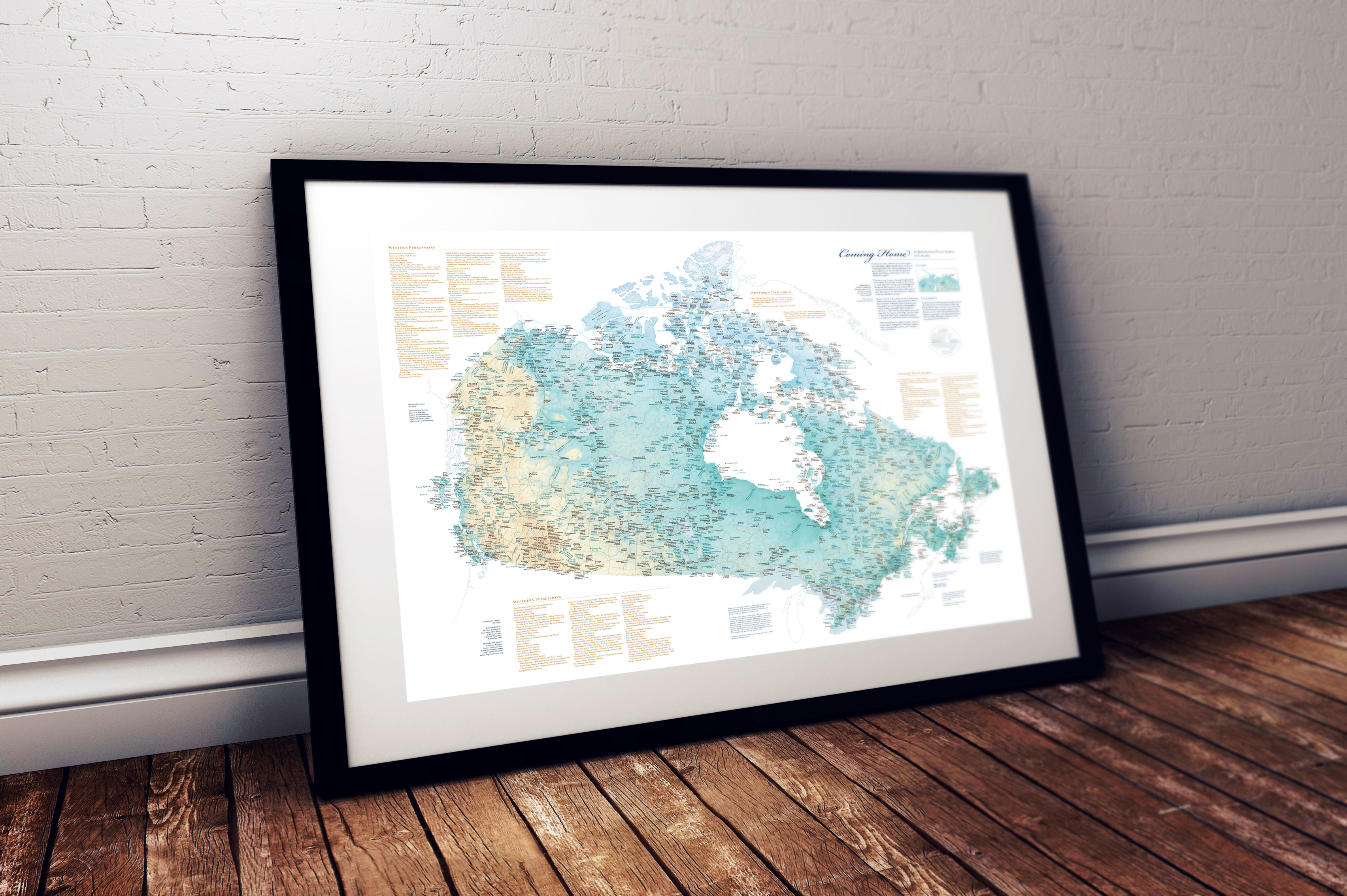
tmackinnon2023-03-04 15:38:112023-05-16 12:48:27Northern Canada Map https://canadiangis.com/wp-content/uploads/Indigenous-Place-Names-in-Canada-map-sm.jpg
1999
3000
tmackinnon
https://canadiangis.com/wp-content/uploads/CanadianGIS-rec-logo-2021-v4.png
tmackinnon2023-02-16 13:50:152023-02-16 13:47:05Indigenous Place Names in Canada Map
https://canadiangis.com/wp-content/uploads/Indigenous-Place-Names-in-Canada-map-sm.jpg
1999
3000
tmackinnon
https://canadiangis.com/wp-content/uploads/CanadianGIS-rec-logo-2021-v4.png
tmackinnon2023-02-16 13:50:152023-02-16 13:47:05Indigenous Place Names in Canada Map https://canadiangis.com/wp-content/uploads/Climate-Atlas-of-Canada.png
480
480
tmackinnon
https://canadiangis.com/wp-content/uploads/CanadianGIS-rec-logo-2021-v4.png
tmackinnon2023-02-14 20:43:182023-02-14 20:41:40The Climate Atlas
https://canadiangis.com/wp-content/uploads/Climate-Atlas-of-Canada.png
480
480
tmackinnon
https://canadiangis.com/wp-content/uploads/CanadianGIS-rec-logo-2021-v4.png
tmackinnon2023-02-14 20:43:182023-02-14 20:41:40The Climate Atlas https://canadiangis.com/wp-content/uploads/2016/07/vancouver_1970_23_5_35_frame_2_grande.jpg
600
800
tmackinnon
https://canadiangis.com/wp-content/uploads/CanadianGIS-rec-logo-2021-v4.png
tmackinnon2023-01-03 18:50:072023-01-13 13:44:13Vancouver Historic Maps and Plans
https://canadiangis.com/wp-content/uploads/2016/07/vancouver_1970_23_5_35_frame_2_grande.jpg
600
800
tmackinnon
https://canadiangis.com/wp-content/uploads/CanadianGIS-rec-logo-2021-v4.png
tmackinnon2023-01-03 18:50:072023-01-13 13:44:13Vancouver Historic Maps and Plans https://canadiangis.com/wp-content/uploads/Nova-Scotia-Civic-Address-Finder.jpg
970
1755
tmackinnon
https://canadiangis.com/wp-content/uploads/CanadianGIS-rec-logo-2021-v4.png
tmackinnon2022-12-02 09:00:242023-01-15 17:09:46Nova Scotia Civic Address Finder
https://canadiangis.com/wp-content/uploads/Nova-Scotia-Civic-Address-Finder.jpg
970
1755
tmackinnon
https://canadiangis.com/wp-content/uploads/CanadianGIS-rec-logo-2021-v4.png
tmackinnon2022-12-02 09:00:242023-01-15 17:09:46Nova Scotia Civic Address Finder https://canadiangis.com/wp-content/uploads/City-of-Saint-John-Maps-Plans-and-Historical-Data.jpg
266
400
tmackinnon
https://canadiangis.com/wp-content/uploads/CanadianGIS-rec-logo-2021-v4.png
tmackinnon2021-05-04 14:14:132023-05-16 16:12:58City of Saint John Maps, Plans and Historical Data
https://canadiangis.com/wp-content/uploads/City-of-Saint-John-Maps-Plans-and-Historical-Data.jpg
266
400
tmackinnon
https://canadiangis.com/wp-content/uploads/CanadianGIS-rec-logo-2021-v4.png
tmackinnon2021-05-04 14:14:132023-05-16 16:12:58City of Saint John Maps, Plans and Historical Data https://canadiangis.com/wp-content/uploads/Atlas-of-Mikmaw-Place-Names.png
266
400
tmackinnon
https://canadiangis.com/wp-content/uploads/CanadianGIS-rec-logo-2021-v4.png
tmackinnon2020-10-30 19:43:562023-05-16 16:23:17Atlas of Mi’kmaw Place Names
https://canadiangis.com/wp-content/uploads/Atlas-of-Mikmaw-Place-Names.png
266
400
tmackinnon
https://canadiangis.com/wp-content/uploads/CanadianGIS-rec-logo-2021-v4.png
tmackinnon2020-10-30 19:43:562023-05-16 16:23:17Atlas of Mi’kmaw Place Names https://canadiangis.com/wp-content/uploads/unnamed-1024x512-1.jpg
512
1024
tmackinnon
https://canadiangis.com/wp-content/uploads/CanadianGIS-rec-logo-2021-v4.png
tmackinnon2020-07-08 19:39:512020-07-08 19:43:14GeoIgnite: Leadership in Times of Disruption
https://canadiangis.com/wp-content/uploads/unnamed-1024x512-1.jpg
512
1024
tmackinnon
https://canadiangis.com/wp-content/uploads/CanadianGIS-rec-logo-2021-v4.png
tmackinnon2020-07-08 19:39:512020-07-08 19:43:14GeoIgnite: Leadership in Times of Disruption