Giant Canadian Floor Map Series
 Giant Canadian Floor Map Series
Canadian Geographic is providing Canadian educators (K to 12) with a new innovative hands-on creative way to teach Canada’s rich geographic history to younger generations.
Their “Giant Floor Map Program” is a free resource that teachers can borrow to help enhance students’ geography experiences through a hands-on, fun creative way to learn. The large giant floor maps of Canada, are created from a heavy-stock vinyl material and cover an area of just over 84 square meters (roughly half the size of an elementary school gymnasium). Each map series also comes with an activity trunk that includes a Teacher’s guide, media kit and pre-planned activities with all required materials.
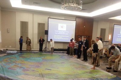
It is really hard to appreciate the true size, resolution and quality of these maps through photos on the web, however one of the maps were displayed at the June CGCRT national workshop that I attended and I must say, these giant floor maps are just as impressive as they sound and certainly will provide many young people with a new perspective for mapping and the spatial extent of Canada.
The Giant Floor maps are available on loan for 3-week periods throughout the school year and by special request during the summer.
The following Giant Floor Maps are available:
- “The War of 1812 – a historical map depicting the main theaters of war set on a backdrop stretching from Fort Detroit to the western tip of Newfoundland and as far south as Baltimore.”
- “Parks Canada: Places and Spaces for Everyone – a topographic map of Canada, highlighting Canada’s national parks, marine conservation areas and historic sites.”
- “Canadian Boreal Forest – a topographic map depicting the vast and valuable boreal forest within Canada’s borders. This map shows all of the aspects related to the groundbreaking Canadian Boreal Forest Agreement, including woodland caribou range, aboriginal treaties and protected areas, as well as forest-product company tenures.”
- “Canada’s Energy: Production and Transmission – a topographic map that shows Canada’s main energy transmission lines, areas of production and energy infrastructure. Students have the opportunity to investigate the critical role that energy plays in Canadians’ lives and how the energy landscape will change in coming years.”
- “Canada from Space – comprised of images taken by Canada’s RADARSAT-2 and is the first of its kind. Explore how Earth observation satellites monitor Canada and can be used to protect and prepare Canadians. Through ten curriculum-linked activities, students will learn first-hand how pollution and natural disasters impact our country, the importance of Canada’s arctic ice, and the scientific phenomenon of the northern lights. They also get a chance to see Canada from the International Space Station, through the eyes of the Canadian astronaut Chris Hadfield.”
For more information on the Canadian Geographic Education’s giant floor map program or to book one of these amazing maps, go to Canadian Geographic
[Image sources: canadiangeographic.ca & tmackinnon.com]


Leave a Reply
Want to join the discussion?Feel free to contribute!