Posts

History of Canada in 10 Maps
/
0 Comments
A History of Canada in 10 Maps consists of several fascinating stories behind some of the people and maps that helped define Canada.

Giant Canadian Floor Map Series
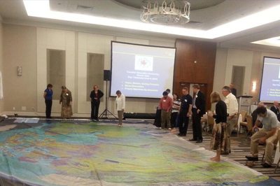
Canadian Geographic is providing Canadian educators (K to 12) with a new innovative hands-on creative way to teach Canada's rich geographic history to younger generations. Their "Giant Floor Map Program" is a free resource that teachers can borrow to help enhance students’ geography experiences through a hands-on, fun creative way to learn.
It is really hard to appreciate the true size, resolution and quality of these maps through photos on the web, however one of the maps were displayed at the June CGCRT national workshop that I attended and I must say, these giant floor maps are just as impressive as they sound and certainly will provide many young people with a new perspective for mapping and the spatial extent of Canada.
The Giant Floor maps are available on loan for 3-week periods ...

Thompson’s 1826 Map of Northwestern North America
I recently returned from giving a presentation at Carto2013; an annual Canadian cartographic themed conference that was held at the University of Alberta co-hosted by the Canadian Cartographic Association (CCA) & the Association of Canadian Map Libraries and Archives (ACMLA).
One of the key themes evident at the conference was related to history of cartography and history through maps", a topic that many of the presentations were related to and several of these talks were about 1826 maps of Northwestern North America created by David Thompson. I myself have never really had much interest in history however these presentations provided me with a much different perspective on history and maybe I have found myself a new (or old??) to explore. Yesterday while searching for some Canadian maps with my daughter I stumbled across yet some more historic themed cartography, so I thought perhaps we should start a new section on CanadianGIS.com related to Historic Cartography since it is pretty evident that this is becoming topic of interest to many in the Canadian Geomatics community.
Find out more about Canadian Geographic Maps & Thompson’s 1826 Map of Northwestern North America ...
