Vancouver Historic Maps and Plans
The City of Vancouver Archives contains over 4000 Vancouver historic maps and plans that have been repaired, restored, scanned, and made freely available to the public to use. The collection is …
The Canadian Geospatial Data Extraction tool is a handy resource provided by Natural Resources Canada that most geospatial users in Canada should get to know. It allows users to extract seamless geospatial open data based on specific user-defined geographic area and data options. This puts the control into the hands of the user while downloading authoritative topographic and elevation data to use in their projects.
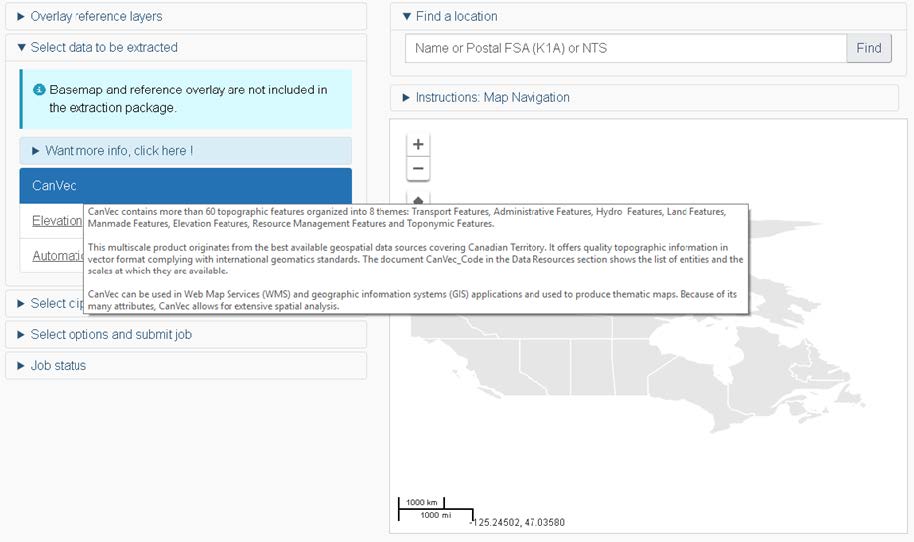
Users can use the Canadian Geospatial Data Extraction tool to extract topographic from the CanVec series, that contains more than 60 topographic features organized into 8 main themes (transportation features, administrative features, hydrographic features, land features, man made features, elevation features, resources management features, and toponymic features). It originates from the best available data sources covering and offers quality topographic information in vector format that complies with international geomatics standards. Because of its many attributes, CanVec data allows for extensive spatial analysis while also being suited to aid cartographic design.
The basic steps to extracting geospatial data is:
See further below for the link to the Canadian Geospatial Data Extraction tool with more details on how to use it.
This section will list all the current geospatial data types that are available for the dynamic data extraction process. If you hover your mouse over the link you will see a description of the data product.
Select one of the product options such as CanVec for topographic data, or Automatic Extraction Data for building footprints from LiDAR data. The tool will then move you to the next section for more options that you need to fill specify based on your selection.
At any time during the process you can always come back to this section and select a different product (note: reference base maps or overlay data shown in the map navigation window will not be included in the download package).
There are a few ways to find your area of interest.
Looking for Nova Scotia Geospatial Data that you can download?
In this section, you select the options for the data set available based on your needs.
Fill out all required and optional fields for the data type and then click the submit button.
After submitting your request, a message should appear at the top of the Canadian Geospatial Data Extraction tool indicating either that your request was successfully submitted or if an error occurred while transmitting the request to the processing server.
Since the data extraction process is not synchronous you will receive an email once your request is completed, and an email will be sent to you containing a download link to data for your specific user-defined geographic area with any other related information on the product you extracted. There is also a job status section at the bottom of the tool that provides some information about your data request.
The email you receive will look similar to this one:
Your request has been processed successfully and you can now download your data using the following link:
https://webservices.maps.canada.ca/fmedatadownload/results/FME_5644441C_1575469714956_5336.zip
Job details :
- Job id : 137247
- Product(s) : Buildings
- Output format : File Geodatabase
- Reference coordinate system : NAD83(CSRS) (EPSG:4617)
Please note that the file will remain available for the next five days only.
For more information on products you received, please see the documentation available here :
If you encounter problems in accessing your file or have questions about its content, please contact GeoInfo Client Services.
All distributed data are subject to the Open Government Licence – Canada.
The City of Vancouver Archives contains over 4000 Vancouver historic maps and plans that have been repaired, restored, scanned, and made freely available to the public to use. The collection is …