The Art of Illustrated Maps
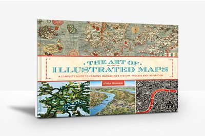 The Art of Illustrated Maps
A Complete Guide to Creative Map making’s History, Process and Inspiration
The Art of Illustrated Maps by John Roman is the first book ever to fully explore conceptual, “illustrated” style mapping. Author, educator and map illustrator John Roman correlates common not-to-scale maps as the “creative non-fiction of cartography,” and in his 208 page book, reveals how and why our minds instinctively accepts the artistic license invoked in creating imaginative maps.
“For the ancients, maps were the most valuable tool in comprehending and conceptualizing the complexities of their planet and the universe.”
The book maps the origins and history of creative cartography, analyzes why our brains so easily relate to conceptual style maps, presents how professional artists create illustrated maps, and showcases some of the works of contemporary map illustrators from all around the world.
http://candiangeo.info/Art-of-Illustrated-Maps




Leave a Reply
Want to join the discussion?Feel free to contribute!