 Maps convey geographic information about places and help us to better understand topography, environment, culture and more.
 https://canadiangis.com/wp-content/uploads/1895-Ottawa-Panoramic-Map.jpg
1220
1578
tmackinnon
https://canadiangis.com/wp-content/uploads/CanadianGIS-rec-logo-2021-v4.png
tmackinnon2019-06-21 08:17:122019-11-21 08:18:081895 Ottawa Panoramic Map
https://canadiangis.com/wp-content/uploads/1895-Ottawa-Panoramic-Map.jpg
1220
1578
tmackinnon
https://canadiangis.com/wp-content/uploads/CanadianGIS-rec-logo-2021-v4.png
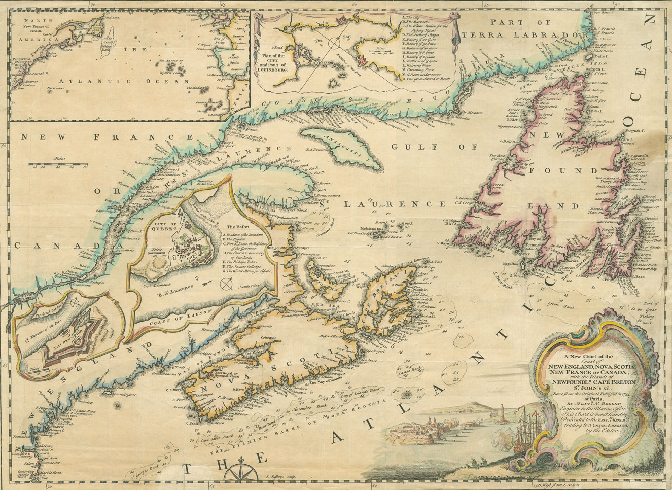
tmackinnon2019-06-21 08:17:122019-11-21 08:18:081895 Ottawa Panoramic Map https://canadiangis.com/wp-content/uploads/Historical-Maps-of-Nova-Scotia.jpg
1081
2115
tmackinnon
https://canadiangis.com/wp-content/uploads/CanadianGIS-rec-logo-2021-v4.png
tmackinnon2019-02-13 11:32:202019-02-13 11:38:00Historical Maps of Nova Scotia
https://canadiangis.com/wp-content/uploads/Historical-Maps-of-Nova-Scotia.jpg
1081
2115
tmackinnon
https://canadiangis.com/wp-content/uploads/CanadianGIS-rec-logo-2021-v4.png
tmackinnon2019-02-13 11:32:202019-02-13 11:38:00Historical Maps of Nova Scotia https://canadiangis.com/wp-content/uploads/Online-Toronto-Historic-Maps.jpg
266
400
tmackinnon
https://canadiangis.com/wp-content/uploads/CanadianGIS-rec-logo-2021-v4.png
tmackinnon2017-12-13 14:30:372017-12-14 09:24:27Online Toronto Historic Maps comparison tool
https://canadiangis.com/wp-content/uploads/Online-Toronto-Historic-Maps.jpg
266
400
tmackinnon
https://canadiangis.com/wp-content/uploads/CanadianGIS-rec-logo-2021-v4.png
tmackinnon2017-12-13 14:30:372017-12-14 09:24:27Online Toronto Historic Maps comparison tool") https://canadiangis.com/wp-content/uploads/W.-H.-Pugsley-Collection-of-Early-Canadian-Maps.png
266
400
tmackinnon
https://canadiangis.com/wp-content/uploads/CanadianGIS-rec-logo-2021-v4.png
tmackinnon2015-11-18 08:00:082017-10-23 21:00:21W. H. Pugsley Collection of Early Canadian Maps (1556 to 1857)
https://canadiangis.com/wp-content/uploads/W.-H.-Pugsley-Collection-of-Early-Canadian-Maps.png
266
400
tmackinnon
https://canadiangis.com/wp-content/uploads/CanadianGIS-rec-logo-2021-v4.png
tmackinnon2015-11-18 08:00:082017-10-23 21:00:21W. H. Pugsley Collection of Early Canadian Maps (1556 to 1857) https://canadiangis.com/wp-content/uploads/Manitoba-Historical-Maps.jpg
259
400
tmackinnon
https://canadiangis.com/wp-content/uploads/CanadianGIS-rec-logo-2021-v4.png
tmackinnon2015-11-15 12:10:052019-02-25 11:08:44Historical Maps of Manitoba
https://canadiangis.com/wp-content/uploads/Manitoba-Historical-Maps.jpg
259
400
tmackinnon
https://canadiangis.com/wp-content/uploads/CanadianGIS-rec-logo-2021-v4.png
tmackinnon2015-11-15 12:10:052019-02-25 11:08:44Historical Maps of Manitoba https://canadiangis.com/wp-content/uploads/Historical-Maps-of-Toronto.jpg
266
400
tmackinnon
https://canadiangis.com/wp-content/uploads/CanadianGIS-rec-logo-2021-v4.png
tmackinnon2015-09-12 11:11:562018-01-06 14:55:39Historical Maps of Toronto
https://canadiangis.com/wp-content/uploads/Historical-Maps-of-Toronto.jpg
266
400
tmackinnon
https://canadiangis.com/wp-content/uploads/CanadianGIS-rec-logo-2021-v4.png
tmackinnon2015-09-12 11:11:562018-01-06 14:55:39Historical Maps of Toronto https://canadiangis.com/wp-content/uploads/Historical-Orthophotos-of-Alberta.jpg
266
400
tmackinnon
https://canadiangis.com/wp-content/uploads/CanadianGIS-rec-logo-2021-v4.png
tmackinnon2015-08-17 11:54:222018-01-06 14:56:12Historical Orthophotos of Alberta
https://canadiangis.com/wp-content/uploads/Historical-Orthophotos-of-Alberta.jpg
266
400
tmackinnon
https://canadiangis.com/wp-content/uploads/CanadianGIS-rec-logo-2021-v4.png
tmackinnon2015-08-17 11:54:222018-01-06 14:56:12Historical Orthophotos of Alberta https://canadiangis.com/wp-content/uploads/Birds-eye-view-of-Victoria-ft.png
266
400
tmackinnon
https://canadiangis.com/wp-content/uploads/CanadianGIS-rec-logo-2021-v4.png
tmackinnon2015-05-27 19:51:072018-01-06 14:59:42Bird’s-eye view of Victoria, BC
https://canadiangis.com/wp-content/uploads/Birds-eye-view-of-Victoria-ft.png
266
400
tmackinnon
https://canadiangis.com/wp-content/uploads/CanadianGIS-rec-logo-2021-v4.png
tmackinnon2015-05-27 19:51:072018-01-06 14:59:42Bird’s-eye view of Victoria, BC https://canadiangis.com/wp-content/uploads/Interactive-Historical-Maps-of-Fredericton.jpg
266
400
tmackinnon
https://canadiangis.com/wp-content/uploads/CanadianGIS-rec-logo-2021-v4.png
tmackinnon2014-06-05 10:29:472019-02-13 20:10:00Interactive Historical Maps of Fredericton
https://canadiangis.com/wp-content/uploads/Interactive-Historical-Maps-of-Fredericton.jpg
266
400
tmackinnon
https://canadiangis.com/wp-content/uploads/CanadianGIS-rec-logo-2021-v4.png
tmackinnon2014-06-05 10:29:472019-02-13 20:10:00Interactive Historical Maps of Fredericton