Posts

Top 5 Skills for a Successful Career in GIS
/
0 Comments
What are the top 5 important GIS skills that a successful professional in the geomatics sector should have?
This 3 part video series presents new ways of thinking about GIS in your career because "skills alone will not guarantee success, but are a fundamental part of it ... "

Giant Canadian Floor Map Series
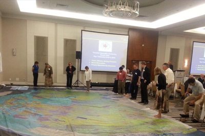
Canadian Geographic is providing Canadian educators (K to 12) with a new innovative hands-on creative way to teach Canada's rich geographic history to younger generations. Their "Giant Floor Map Program" is a free resource that teachers can borrow to help enhance students’ geography experiences through a hands-on, fun creative way to learn.
It is really hard to appreciate the true size, resolution and quality of these maps through photos on the web, however one of the maps were displayed at the June CGCRT national workshop that I attended and I must say, these giant floor maps are just as impressive as they sound and certainly will provide many young people with a new perspective for mapping and the spatial extent of Canada.
The Giant Floor maps are available on loan for 3-week periods ...

Trent University Geography Degree with GIS
The Geography department at Trent University has a strong emphasis on field based hands on learning with interdisciplinary study. Many of their courses are mixed with other departments and programs such as the Geographical Information Systems (GIS) program witch is associated with Geomatics at Fleming College.

What can you do with Geography?
"We all know that geography is important; but what can you do with it?" Here we explore how geography is used in the real world, from disaster response to military intelligence and even polar exploration.

St. John’s Declaration (Help Improve Geographic Literacy in Canada)
Last month at the Canadian Association of Geographers conference in St.John's, Newfoundland, a group of concerned geography educators came together to discuss deficiencies in geographic knowledge, work on a strategy and create an action plan to help geographic education in Canada. St. John’s Declaration is a document that resulted from the meeting that will be sent out to all the major educational institutes and professional organizations to seek their endorsements for the cause.
“The Canadian GIS & Geomatics website has been a long standing supporter of Geography & GIS Awareness in Canada, and in support geographic learning, teaching and research that is the foundation of the Canadian geomatics sector, supports the St. John’s Declaration for Advancing Geographic Education.”

Thompson’s 1826 Map of Northwestern North America
I recently returned from giving a presentation at Carto2013; an annual Canadian cartographic themed conference that was held at the University of Alberta co-hosted by the Canadian Cartographic Association (CCA) & the Association of Canadian Map Libraries and Archives (ACMLA).
One of the key themes evident at the conference was related to history of cartography and history through maps", a topic that many of the presentations were related to and several of these talks were about 1826 maps of Northwestern North America created by David Thompson. I myself have never really had much interest in history however these presentations provided me with a much different perspective on history and maybe I have found myself a new (or old??) to explore. Yesterday while searching for some Canadian maps with my daughter I stumbled across yet some more historic themed cartography, so I thought perhaps we should start a new section on CanadianGIS.com related to Historic Cartography since it is pretty evident that this is becoming topic of interest to many in the Canadian Geomatics community.
Find out more about Canadian Geographic Maps & Thompson’s 1826 Map of Northwestern North America ...

Niagara College
At Niagara College they combine GIS, remote sensing and geodatabase management together throughout the three terms. The one year GIS Certificate program at Niagara on the Lake Campus includes a thesis project that students work on for the whole term while working along side with employers to help design and implement real world GIS projects.

1917 Vancouver Mission Route Map
Today we have a scan of a Vancouver Mission (British Columbia) Route Map taken from The Automobile Blue Book published in 1917.
 https://canadiangis.com/wp-content/uploads/Halifax-Ferry-1.jpg
556
1024
tmackinnon
https://canadiangis.com/wp-content/uploads/CanadianGIS-rec-logo-2021-v4.png
tmackinnon2013-01-15 08:39:522017-08-15 09:22:31GIS jobs in Halifax