Posts

Using Location Hub to Unlock the Power of Location Economics
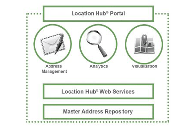
Recently I had an opportunity to talk 'one on one' with Arthur Berrill, CTO of DMTI Spatial; a Canadian geomatics based company that has been a leader in the Location Business for several years. DMTI Spatial is a Canadian based company that has been providing industry-leading enterprise Location Economics solutions for almost two decades. They started off by designing a comprehensive and tightly integrated national street network database known as CanMap®, and have evolved to integrate Location Economic solutions through Location Hub® combined with a database of unique address identifiers (UAID).
Unlike traditional GIS that is typically built around X, Y coordinate values with attribute information and designed for more technical people whereas location analytic services uses an address as the key approach to connect attributes while defining the location spatially at the same time. When you stop and think about it, almost nothing in everyday life uses coordinates to define locations, yet nearly all data contains address based information, therefore it makes perfect sense to have Location Hub® start with the addresses and then build a GIS behind the scenes, leveraging the most comprehensive base data available in Canada. ...

DMTI Spatial chosen as provider of geospatial data to the Federal Government
/
0 Comments
DMTI Spatial, a Canadian location intelligence company, has recently been awarded the Domestic Vector Data Set contract by the Ministry of Public Works and Government Service Canada (PWGSC) as a result of the exceptional quality of its CanMap® geospatial datasets. The exclusive contract will provide numerous government departments with critical location-based information to help make vital policy and planning decisions.
In the past, the Canadian government has used DMTI Spatial’s data to support the operations of the 2010 Vancouver Olympics, the 2010 G20 Summit in Toronto and the G8 Summit in Huntsville, among other initiatives. This contract provides various federal government departments with critical location-based information to help make important policy and planning decisions affecting the lives of all Canadians.
