Geomatics Yukon GIS Data and Yukon Lands Viewer

Geomatics Yukon GIS Data and Yukon Lands Viewer
Geomatics Yukon is the online portal location where you will find GIS open data and imagery for the Yukon Territory. It hosts and distributes a wide range of web mapping applications and spatial data for several Yukon Government departments and partners that allow people to search their growing collection of available data sets.
Although most data from Geomatics Yukon is freely distributed and available to the public including Imagery; some of the satellite imagery that they have is licensed only to the Yukon Government so is only available to project partners and First Nations governments on request, though the website and requires an Imagery Use Agreement to be completed first.
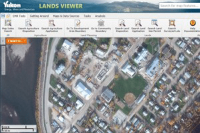
Geomatics Yukon offers an online web mapping through the Energy, Mines and Resources Yukon Lands Viewer. It is built upon an Esri server with Geocortex by Latitude Geographics providing powerful well-rounded mapping tools and innovative features for a wide range of experienced and not so experienced end users.

The Yukon Lands Viewer like many other Esri based web served applications provides many useful tools and applications from searching data sets to customizing your own map. They provide the ability to incorporate your own data from shape files or CSV data as well as the ability to draw and edit features and then print or export your results. A pretty detailed instruction manual can help those that run into troubles with the map viewer.
Geomatics Yukon aims to provide a central source for distributing Yukon government spatial data and imagery and although some what limited it is off to a good start in becoming an opendata portal.
Yukon GIS Data Web links:
- http://mapservices.gov.yk.ca/GeoYukon/
- http://www.geomaticsyukon.ca/data/datasets
- http://www.environmentyukon.ca/geomatics/data.html
[originally published Sept 22, 2013]


Leave a Reply
Want to join the discussion?Feel free to contribute!