New Canadian Geodetic Vertical Datum

New Canadian Geodetic Vertical Datum
Geodetic reference systems stem from the need to have a consistent integrated reference surface for data analysis in applications such as surveying, cartography, navigation, remote sensing and mineral exploration. National Resources Canada (NRCan) maintains the Canadian Spatial Reference System (CSRS), through the use of the North American Datum of 1983 (NAD83CSRS) and has been an adopted standard in Canada.
NRCan has recently made a new Canadian Geodetic Vertical Datum available: CGVD2013, which is now the new reference standard for Canadian reference heights. This new height reference system replaces the Canadian Geodetic Vertical Datum of 1928 (CGVD28), which was adopted officially by an Order in Council in 1935 and has been used by organizations and individuals coast to coast for the past few decades.
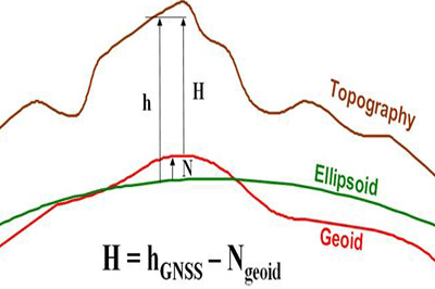
“CGVD2013 is defined by the equipotential surface ( W0=62636856,0m2s?2 ), which represents by convention the coastal mean sea level for North America. This definition comes from an agreement between the United States of America and Canada. This new vertical datum is realized by the geoid model CGG2013, which provides the separation between the GRS80 ellipsoid and the above described surface in NAD83(CSRS) reference frame, making it compatible with Global Navigation Satellite Systems (GNSS) such as GPS.
The height of the benchmarks is also available in CGVD2013. These heights come from a readjustment of the entire federal first-order levelling network. However, CGVD2013 heights obtained from GNSS and geoid model CGG2013 prevail over the published elevations because NRCan cannot confirm the accuracy of the heights and stability of the benchmarks derived from the aging levelling network.
NRCan is continuing the publication of heights at benchmarks in CGVD28 and hybrid geoid model HTv2.0 to assure a smooth and gradual transition period to the new height reference system.”
CGG2013 is the Canadian gravimetric geoid model of 2013 realizing the Canadian Geodetic Vertical Datum of 2013 (CGVD2013). The model comes with an accuracy model for the geoid heights. CGG2013 can be downloaded through the NRCan Geoid Models page. (User account required, but it is free to signup for one)
[image source: nrcan.gc.ca]
 Surveying")


Leave a Reply
Want to join the discussion?Feel free to contribute!